Introduction
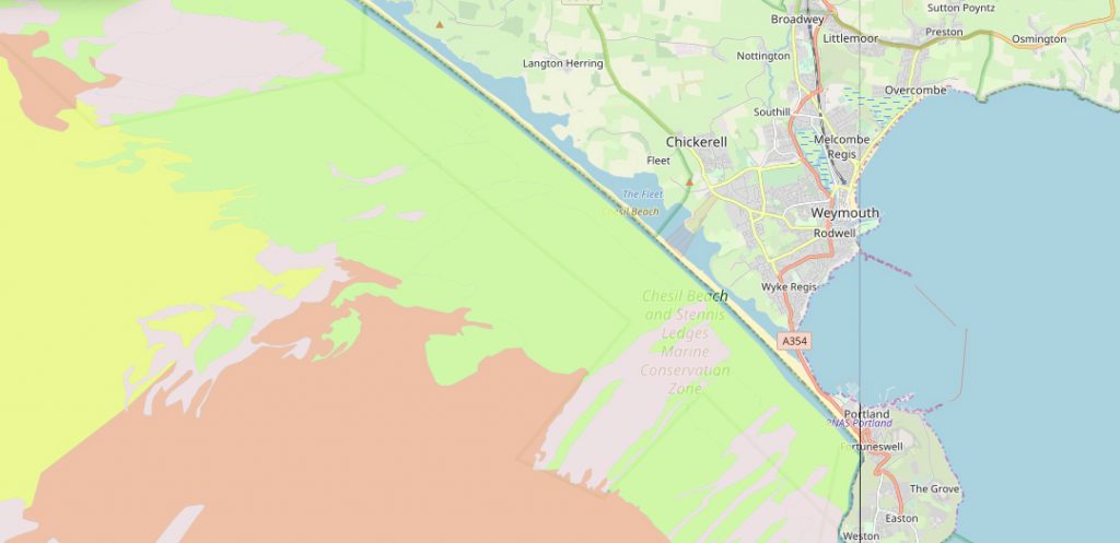
An immense, 18-mile, golden bank of shingle stretching from Portland to West Bay, Chesil Beach is an unmistakeable and striking landmark on the Dorset coast. The beach forms the landward boundary of the Chesil Beach and Stennis Ledges Marine Protected Area – an inshore MPA encompassing some 3,700 hectares of seabed.
The Chesil and Stennis MPA was designated in November 2013 and protects the rocky ridges and rugged seabed of the Stennis Ledges and much of the length of the seabed along Chesil Beach. The rocky and gravel habitats within the MPA support commercial species like crabs and lobsters and our native oysters which are under pressure from invasive, non-native species.
Like Lyme Bay MPA, the site is also home to pink seafan soft corals which are slow-growing and sensitive to damage. Chesil Beach, the Cove in particular, is very popular with divers who come to see the reefs, wrecks and colourful marine life. Year-round, Chesil beach is lined with anglers targeting fish like mackerel, bass, turbot or plaice while a small number of local vessels fish with pots or low-impact nets.
Chesil Cove and Stennis Ledges are toward the eastern end of Chesil Bank. Subjected to south-westerly Atlantic swell and regular storms, these high-energy areas support sturdy and robust wildlife capable of withstanding the forces of nature.
Chesil Beach is a popular angling location throughout the year and commercial boats still operate from Chesil Cove.
(Image credit – Jim Linwood, Creative Commons 2.0)
Protected Features
The Chesil Beach and Stennis Ledges MPA has several protected habitats and species. These are monitored to ensure they remain in good, healthy condition and are not adversely affected by human activities. These protected features are described below…


Seabed Features
Forming part of the East Devon and Dorset Jurassic Coast World Heritage Site, Chesil Beach (or Bank) is 18 miles long and on average 160m wide, reaching 200m wide in places. The beach is a striking landmark and a major feature of the Dorset coast.
Chesil is a shingle and pebble ‘tombolo’ meaning it is a landform made of deposited material joining an island to the mainland.
The exact processes which helped form Chesil Beach are debated often. One recent view is that the beach formed initially from sand, shell and coarser deposits in Lyme Bay as sea levels rose rapidly some 14,000 to 20,000 years ago at the end of the last Ice Age. These deposits were gradually driven onshore and eastward, eventually forming the Fleet Lagoon around 5,000 to 7,000 years ago.
Crumbling cliffs in east Devon are thought to have supplied huge quantities of gravel, perhaps up to 60 million cubic metres. This was then transported via longshore drift and driven onto the beach.
Today, human coastal development in the region means the natural re-supply of fresh gravel to Chesil Beach has been cut off, placing it at risk from rising sea levels.
The full report on the formation of the beach by Malcolm Bray of Portsmouth University is available HERE.
The Dorset Integrated Seabed survey (DorIS) mapped the Dorset seabed using sonar technology. This gave accurate information about the local seabed features.
On the map you can explore the seabed features within the MPA boundary and take a look at other incredible undersea formations around the Dorset coast. If using a touch screen, use two fingers to zoom and scroll.
Seabed maps showing the different rocks and sediments in the Chesil Beach and Stennis Ledges MPA based on available survey data can be viewed via the European Marine Observation and Data Network.
The DorIS seabed map shows that the underwater geology in the Chesil Beach and Stennis Ledges MPA has many sharp transitions across the site. Stennis Ledges themselves are obvious as a distinct set of ridges and rough ground perpendicular to Chesil Beach. These rocky exposures allow a whole manner of species of hard and soft corals, sponges, sea squirts, hydroids and bryozoans to live, grow and create reefs full of life.
Away from the ledges inside the MPA the seabed is a mix of sands and gravels, save for some further rocky outcrops and rough ground approximately opposite the village of Langton Herring.
The Ledges, areas of rough ground and rocky reefs around Chesil Cove are productive areas for pot fishermen working from Weymouth, West Bay and Chesil Cove itself.
The MPA has habitats ranging from kelp beds and rocky reefs with overhangs and crevices, to areas of wide open seabed of sand and gravel. Here a leopard-spotted goby and tompot blenny shelter beneath an overhang as a starfish passes slowly by.
Habitats and species
Chesil Beach and Stennis Ledges lie at the eastern end of Lyme Bay and support some the easternmost examples of several south-western marine species. Pink seafans for example are found in good numbers on Stennis Ledges. They can be found east of Portland but they are few and far between and seldom found in the vast meadows so characteristic of Lyme Bay.
Commercial fish and shellfish such as mackerel, bass, pollack, plaice, turbot, lobster and crab are all found in the MPA. In summer it is possible for divers to sit and watch pollack and bass hunting sandeels over open sand in Chesil Cove, whilst huge grey mullet patrol the shallows, feeding on algae-covered rocks.
The galleries and videos in the sections below provide an insight into the wonderful and varied sealife found within this MPA. The word cloud provides links to some of the more commonly recorded species in the MPA.
Chesil Cove
Chesil Cove, where Chesil Beach meets Portland can provide ideal conditions for divers to explore the local marine life, when the weather is good.
The shingle beach shelves steeply down and the pebbles and cobbles quickly turn to a mix of coarse sands, gravels and boulders, some the size of cars. These rocky areas support kelp forests, other algae, anemones and numerous sponges. Larger boulders create overhangs and crevices – ideal hiding places for lobsters, conger eels and dogfish.
Between the rocky areas are wide areas of coarse sand and gravels. These are ideal homes for sandeels with cuttlefish, rays and flatfish also making regular appearances.

ROLL over each image to find out more. CLICK on each image to see a larger version. ESC to return to the main screen.
TAP each image ONCE to find out more, TWICE to see a larger version. Tap off the image to return to the main screen.
return to the main screen.
Local diver Colin Garrett has been filming the marine life in Chesil Cove for the past few years. Colin often dives at night and has had some incredible encounters with all sorts of marine life after dark. Check out this selection of Colin’s wonderful videos of life beneath the waves in Chesil Cove and see if it makes you feel the urge to take the plunge as well!
Stennis Ledges
Stennis Ledges is a series of distinct rocky ridges and rough ground extending at a right angle to Chesil Beach. Being in deeper waters, known as ‘circalittoral‘ where less light reaches, the area supports few algae. Instead the rocks are festooned with sponges, hard and soft corals, colonial hydroids and bryozoans.
The gallery below shows a small selection of the life found here.
ROLL over each image to find out more. CLICK on each image to see a larger version. ESC to return to the main screen.
TAP each image ONCE to find out more, TWICE to see a larger version. Tap off the image to return to the main screen.
return to the main screen.
Elsewhere in the MPA are several shipwrecks, one of the most famous being the Royal Adelaide, which is diveable from the shore across from the Chesil Beach Visitor Centre car park. The Royal Adelaide was carrying cargo including gin and brandy from London to Sydney when a storm forced her into Lyme Bay on 25th November 1872.
Local people helped save all but seven of the 67 souls on board. However a further four locals perished from exposure after becoming drunk on the cargo and spending the night on the beach.
Local diver Colin Garrett’s video shows that nowadays what remains of the Royal Adelaide is an oasis for marine life amongst the relatively barren mobile shingle that forms the base of Chesil Beach.
Countless ships have perished on Chesil Beach across the centuries. Often nothing, or almost nothing remains owing to the many storms that batter the beach each winter. But some of the more sturdy structures do persist and these can be dived from the beach at certain places.
Each year in late summer to early autumn when our waters are often at their warmest, the Royal Adelaide is a draw for oceanic triggerfish. These strange looking fish swim using their dorsal and anal fins in what is called ‘balistiform swimming.’
Further along the beach, a wrecked WWII landing craft, the LCT(A) 2454 provides another home for marine life. Colin Garrett’s videos below illustrate this in all its glory.
Whilst perilous to some mariners, Chesil Beach has long-offered protection from the sea to those living on the landward side, as well as productive fishing grounds when the seas are calm.
This old fishing boat called a lerret was the vessel of choice for seine net fishing from Chesil Beach. Its wide beam with both a pointed bow and stern allowed the net to be paid out from either side without needing to first turn the boat around.
People and management
Chesil Beach has long been an important fishing ground for local people. As in Lyme Bay, fishermen would have historically deployed fixed gears (pots and gill nets), drift nets, hand lines (feathering) and seine nets to catch fish and shellfish like mackerel, herring, flatfish, lobster, crabs and prawns.
Although just outside the Chesil Beach and Stennis Ledges MPA, the Burton Bradstock Village website gives valuable insight into the traditional fishing techniques used along Chesil Beach, including more images of lerrets like the one above.
Today one or two old dis-used lerrets still scatter the shoreline of the Fleet Lagoon. In 2015 the Chesil Bank and Fleet Nature Reserve donated an old lerret called Silver Star (built in 1914) to the Castletown Regeneration Project which is now on display in Castletown, Portland.
The ‘Beachcombers’ program from 1975 shows local fisherwoman Ginny Arnold using a traditional seine net from Chesil Beach. The footage can be viewed between five and nine minutes into the program.
Archive footage from 1948 shows other fishermen deploying a seine net and retrieving their catch of mackerel from Chesil Beach.
Fishing today
Chesil Beach is often lined with anglers throughout the year targeting fish like mackerel, bass, cod, turbot or plaice; it is a nationally important site for the pastime. A number of local vessels carry out commercial potting for whelks, crabs, lobster and in the springtime, for cuttlefish.
Low levels of net fishing occur in the MPA for species like sole, plaice and various rays. Bottom-towed fishing gear is used outside of the site’s ‘bottom-towed fishing prohibited areas’ and targets species like plaice and sole. Scallop dredging also still occurs.
Management of fishing activity within the MPA is undertaken by the Southern Inshore Fisheries and Conservation Agency (SIFCA). SIFCA is responsible for ensuring that fishing activities do not adversely impact the protected features of the MPA.
Management plans are being drawn up as part of the ‘Community Planning in MPAs’ project. This project is carried out in partnership with Dorset Wildlife Trust and funded by the Dorset and East Devon Fisheries Local Action Group (FLAG). The project aims to provide relevant information on the value of the MPA and detail how fishers can support management and enhance the site’s value. A series of workshop events in December 2018 combined with other stakeholder consultation and additional research into ‘best practice’ is being used to develop the MPA management plan.


(Image credit Andrew Smith, Creative Commons License 2.0)
Other sea users
Having MPA status is not just intended to improve commercial fisheries. Recreational sea anglers and divers can expect to enjoy greater value from the site as conservation measures start to have a noticeable effect like a greater diversity and abundance of fish and other species.
In addition to the shipwrecks that line Chesil Beach the important marine life that the site supports such as colourful reefs and pink seafans attract divers to the area. Chesil Cove itself is hugely popular with divers who flock to the beach in spring and summer when conditions are good. Diving further offshore requires a boat and the area is popular with Seasearch divers who have contributed to the evidence of the sea life in the MPA.
Today the unique nature of Chesil Beach and the adjacent Fleet Lagoon attracts up to 150,000 visitors each year.
People visit for bird watching, sea angling, walking, site-seeing and educational field trips e.g. ecology or geology. Dolphins, harbour porpoises, sometimes even orcas, as well as nationally rare seabirds attract wildlife watchers to the area.
Protection of the site through appropriate management measures has the potential to increase numbers of these species and encourage more people to visit the site.
Management in a nutshell – DRAFT plans
For most fisheries, the MPA is within the jurisdiction of the Southern IFCA, although migratory species come under the remit of the Environment Agency. In addition to all relevant national and EU fisheries legislation, all Southern IFCA District-wide byelaws apply to this MPA, and out to six nautical miles.
Marine life within the MPA is subject to several fishing methods, each requiring a certain level of management to ensure the activities remain sustainable.


Pot fishing
Fishing vessels from Weymouth and West Bay visit the site using baited pots to fish for crab and lobster over Stennis Ledges and smaller reefs off Langton Herring. Whelk pot and cuttlefish trap fisheries also occur seasonally throughout the site. Pot fishers must comply with national and international minimum conservation reference sizes.
Management of fishing activities is rarely a static process and fisheries are subject to constant review by Southern IFCA.
Sea angling
Sea angling from Chesil Beach is mostly recreational and the area can see hundreds of anglers present on popular days. Fishing can be concentrated around several access points with car parks, whilst more determined anglers might row across the Fleet at certain points or walk long distances along the beach to reach preferred locations. Anglers assign great value to the site because of the diversity of fish species available.
While it is important that fishing activities are sustainable, the importance of the social and economic value of sea angling to the local community must be considered in any management plan.
The Southern IFCA ‘Fishing under mechanical power – closed area’ legacy byelaw places seasonal prohibition of fishing trawls within 1nm of Chesil Beach from a point close to Langton Herring and northwest to Golden Cap. This historic byelaw reduces conflict between trawlers and recreational sea anglers and supports the access for Chesil Beach’s anglers to fish populations.
Dredge and trawl fishing
Southern IFCA has introduced management to prohibit bottom-towed fishing gear (scallop dredging and trawling for flatfish) in three parts of the MPA to protect fragile reef communities and to encourage recovery of the pink sea fan population. Dredge and bottom-trawl fishing remain permissible within the MPA between these protected areas.
For more detailed information on the fishing management within the MPA, see the full management plan on the IFCA website.
Looking to the future
Natural England is responsible for monitoring the MPA and assessing the condition of its protected features. If any evidence arises about potential impacts to these features from commercial fishing, Southern IFCA would assess the evidence and consider the necessary management response.
Southern IFCA aims to achieve compliance with fishing regulations in the MPA through a combination of education, monitoring and enforcement. Throughout Dorset patrols are carried out at day, night and on weekends year-round, in patrol vessels and on foot in ports and harbours. The catches, landings and fishing gears of vessels (recreational and commercial), anglers and divers can be inspected.
If non-compliance occurs, Southern IFCA can issue warnings, financial penalties or prosecute offenders.
Meetings through groups such as the Dorset Coast Forum, Dorset and East Devon Fisheries Local Action Group (FLAG), Dorset Wildlife Trust and Southern IFCA continue to ensure that stakeholders and regulators engage with one another on a regular basis. The MPA Community Planning project funded by the Dorset and East Devon FLAG is one such project which held initial workshops in 2018 to engage with the various groups using MPAs and help shape future management plans.
The on-going monitoring, enforcement, education and discussion aims to ensure healthy and productive local seas are secured and improved for future generations.


